
Comment on the Heat Island Criteria filed in NYS PSC Case 24-M-0586
Benjamin Q. Huynh, Jennah Gosciak, Elizabeth T. Chin, Allison Koenecke
In short
Submitted to the New York State Public Service Commission. Utility companies in New York were granted the authority to define heat island boundaries throughout the state, which would identify which communities were eligible for extra protected days from utility shutoffs during heat waves. We re-implemented the proposed heat island criteria and found that making small plausible changes to the criteria could shift coverage for hundreds of thousands of residents. We make some technical recommendations, as well as promote procedural justice and community co- development of heat island criteria.
We write on behalf of The Upstream Evidence Project, a collective of scientists and policy experts who conduct public policy research. We appreciate the opportunity to comment on what the utilities filed June 1–10, 2026 under Ordering Clause 7 of the March 19, 2026 Order: each utility’s criteria for identifying heat islands, its list of the heat islands those criteria identify, and the boundaries of each.1
To prepare these comments, we re-implemented the proposed methodology of identifying heat islands and conducted subsequent analyses to assess sensitivity. Our comments and findings are as follows.
Compare alternative criteria for identifying heat islands
Ordering Clause 7 provides that the Commission “will consider whether to adopt, modify, or reject, in whole or in part, the filed heat island list and criteria on a permanent basis following a comment period.” Thus far, the technical conferences that produced the criteria have examined several elements of the criteria, such as the data source, the geographic unit, or whether the threshold should be 2.5, 2.0 or 1.0°F.2 Comparative analyses for alternative criteria beyond the aforementioned parameters have not yet been extensively conducted.
The filings score each urban block group by its modeled hottest-hour air temperature or heat index minus the mean of the rural block groups within 30 km of its Urban Area.3 This approach is only one of many defensible approaches to turn the Department of Environmental Conservation’s (DEC) dataset into a heat island score. In our analysis, we find that varying between plausible criteria for heat island determination would have large downstream implications in terms of which residents are included. We therefore recommend (1) carefully choosing between criteria; (2) providing clear, scientific justification as a basis of determination; and (3) conducting sensitivity analyses as we have to evaluate how New Yorkers may be impacted differently by different candidate criteria.
As a plausible alternative, the DEC dataset itself already includes an Urban Heat Island Effect layer, defined as the difference from the coolest land pixel within each urban area, as described at the April 15, 2026 conference (“calculate difference from coolest pixel within each urban area”).4 Other plausible specifications include absolute temperature and the land-cover inputs to the model. We held each of them at the same statewide count as the set the filed criteria select statewide (10,339 block groups; 13,430,695 residents), evaluating how much membership in heat islands would change under different definitions.
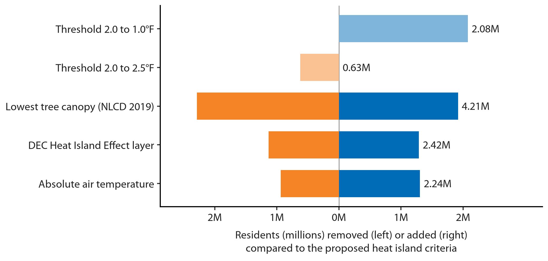
Our findings show that these different plausible measures have large impacts in terms of which New Yorkers are included in the designation. We are not advocating for any particular definition of heat island, but instead recommend the discussion over the definition of the term (1) be made more clear to New York communities in terms of how different definitions may include or exclude different populations; and (2) include clear scientific justification for a final choice. Our research has shown this effect in other algorithmic designations, finding that reasonable alternative ways of measuring the same thing often produces different assignments, and the parameters that receive public debate are often not the ones that matter most.5,6 As is, we recommend the Commission continue the interim designations as filed, decline to adopt the proposed criteria permanently in their current form, and direct a comparison of measures on the record: the proposed criteria, the DEC Heat Island Effect layer, and a nighttime measure (discussed below), with each compared in terms of residents included and excluded, by geography.
Temperature error is unquantified at the block group-level
The DEC dataset underlying the proposed heat island criteria uses the output of i-Tree Cool Air, a model that takes regional air temperature from 28 weather stations, interpolates data across the state, and adjusts based on information such as land cover and elevation.7,8 Such model-based approaches typically work well at lower resolution (i.e., larger areas), but may introduce errors at higher resolutions (smaller areas), as they use few actual measurements and may “smooth“ out urban-scale differences in temperature that could only be truly captured by hyper-local sensors.9,10
Every filing adopts moving from Census places in 2026 to Census block groups in 2027 to define heat islands. By our estimate, this switch could reduce coverage by between 341,214 and 985,416 residents, depending on how the filed lists are counted.1 We request time for more information regarding block group-level error, as switching to block groups requires increased precision, and it is not clear whether existing precision is sufficient to accurately map out the heat island at granular detail.
The filings cite a ±1.8°F instrument tolerance as the margin of error for the weather station data underpinning the DEC dataset and therefore the proposed heat island criteria.3,11 By our estimates, 4,426 block groups, corresponding to 5,584,026 residents, lie within ±1.8°F of the 2.0°F threshold, indicating over a quarter of the state’s population is within the margin of error for heat island eligibility. Such statistical noise would be more easily absorbed by a larger geographical unit than a block group.
Furthermore, this instrument tolerance does not incorporate noise from modeling error. Both the magnitude of this noise, and whether some regions are more affected than others remains undocumented. We were unable to find materials with uncertainty intervals for DEC’s temperature estimates and so were unable to estimate the uncertainty ourselves. It is for these reasons that we recommend that the April 1, 2027 switch to block groups not take effect until DEC have stated a block-group-scale error for the hottest-hour products and the filed margins have been compared with it.
Evaluate a nighttime measure before the criteria are made permanent
The motivation for providing two additional protected days for heat islands is driven by the fact that heat islands are slower to cool off at night.4 However, the proposed heat island criteria score block groups by the hottest daytime hour, and do not appear to incorporate nighttime temperatures. It stands to reason that nighttime temperatures should be considered when developing criteria for heat islands.
DEC’s methods page states that its 300 m hourly and daily products, including daily minimum temperature, “will be available for download in 2026.“7 Preliminary versions of such tools appear to be online at the live DEC website. Considering daily minimum temperatures as part of the criteria may be useful in comparing different measures, and we recommend doing so once the full data products are available.
Further considerations
Lastly, the definition of heat islands as used in the proposed criteria is narrow: other scientific definitions account for other environmental factors such as housing stock or access to cooling. The sensitivity to many plausible different designs as well as the lack of actual urban-scale temperature readings indicate that proposed definitions of heat island boundaries may be premature. We therefore recommend establishing a formal process by which residents, local governments, scientists, and community based organizations can review and co-develop heat island designations before permanent adoption.
Conclusion
Extreme heat will remain a growing challenge for New Yorkers, and establishing rigorous methodologies for identifying heat islands would be a step towards future community resilience. Con Edison has been provided an extension to file until April 2, 2027. We believe comparing different heat island criteria between now and then would allow the Commission to set permanent criteria under a more informed context and less urgent timeline, considering Summer of 2026 is already coming to a close.
Please feel free to contact us at bhuynh@upstreamevidence.org should you have any questions. Thank you for your consideration.
This comment is submitted on behalf of The Upstream Evidence Project. The views expressed herein are solely those of the Project.
References
1. New York State Public Service Commission. Notice Seeking Comments, Case 24-M-0586. Issued July 23, 2026.
2. NYS Department of Public Service Staff. Extreme Heat Technical Conference Letter with Appendix, Case 24-M-0586. Staff letter (K. Whitaker) pp. 1–5; appendix: Staff email of May 22, 2026, the utilities’ joint summary of May 28, 2026, and comments from PULP, WE ACT and State legislators. Issued July 23, 2026.
3. Central Hudson Gas & Electric Corporation. Heat Island Criteria, Case 24-M-0586. Filed in DMM as “Heat Islands Compliance.” The methodology text (pp. 3–6), the ±1.8°F justification and the three-parks passage (p. 5) appear in substantially identical form in the National Grid, Veolia, Liberty, O&R and NYSEG/RG&E filings. Filed June 1, 2026.
4. NYS Department of Environmental Conservation and NYS Department of Health and Central Hudson Gas & Electric Corporation and Consolidated Edison Company of New York, Inc. and Orange and Rockland Utilities, Inc. and Public Utility Law Project of New York. Technical Conference Presentations, Case 24-M-0586. NYS DEC Office of Climate Change, “Extreme Heat Action Plan: Urban Heat Island (UHI) mapping”; NYS DOH (N. Muscatiello), list of tools used at the April 16 session; Central Hudson, “Preliminary Heat Island Identification” (April 15); Con Edison and Orange & Rockland (B. Cerruti), “Preliminary Urban Heat Island Methodology”; PULP, “Extreme Heat Protections: Heat Island Framework Criteria Proposals” (April 2026). Sessions of April 15–16, 2026.
5. B.Q. Huynh, E.T. Chin, A. Koenecke, D. Ouyang, D.E. Ho, M.V. Kiang, and D.H. Rehkopf. Mitigating allocative tradeoffs and harms in an environmental justice data tool. Nature Machine Intelligence, Nature Publishing Group UK London, 6(2):187–194, 2024.
6. J. Gosciak, L. Boyce, A. Wang, and A. Koenecke. Scrutinizing index-based risk assessments: A case study in NYC decision-making for heat emergency management. The 2026 ACM conference on fairness, accountability, and transparency, :6659–6701, 2026.
7. NYS Department of Environmental Conservation and SUNY College of Environmental Science and Forestry and Davey Institute. New York State Urban Heat Islands: Hottest Hour block-group aggregates (NYSUHI_1_BlockGroup, built October 4, 2024) and methods page. https://nys-heat.daveyinstitute.com/hottest-hour/; methods page https://nys-heat.daveyinstitute.com/hottest-hour/methods.html. Retrieved September 1, 2026.
8. Y. Yang, T.A. Endreny, and D.J. Nowak. A physically based analytical spatial air temperature and humidity model. Journal of Geophysical Research: Atmospheres, Wiley Online Library, 118(18):10449–10463, 2013.
9. V. Shandas, J. Voelkel, J. Williams, and J. Hoffman. Integrating satellite and ground measurements for predicting locations of extreme urban heat. Climate, MDPI, 7(1):5, 2019.
10. C.D. Ziter, E.J. Pedersen, C.J. Kucharik, and M.G. Turner. Scale-dependent interactions between tree canopy cover and impervious surfaces reduce daytime urban heat during summer. Proceedings of the National Academy of Sciences, National Academy of Sciences, 116(15):7575–7580, 2019.
11. National Weather Service. Automated Surface Observing System (ASOS) User’s Guide. Table 1 (p. 12), ambient temperature sensor: RMSE 0.9°F, maximum error ±1.8°F. https://www.weather.gov/media/asos/aum-toc.pdf, March 1998.
Footnotes
-
The upper figure applies the filed Place-assignment rule to every territory in the state, including Con Edison, whose heat island filing has been deferred to 2027. The lower figure counts only the territories of the utilities that filed lists, using the Places named in their filings. ↩